LAKESHORE EAST DIALOG
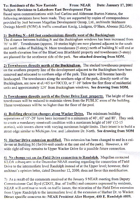
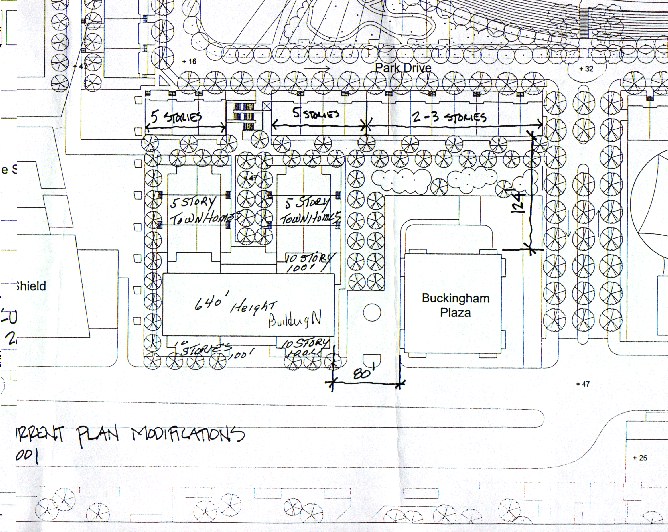
Questions submitted by Richard F. Ward (312-938-0884)
NEF (New Eastside Forum) QUESTIONS 1 thru 6 were simply about the Plan Commission hearing timetable, etc. The more difficult questions on January 4, 2001 were directed to Benet Haller, the project coordinator of the Chicago Department of Planning and are the following:
NEF 7 QUESTION (1-4-01) When will the layout of the buildings be available?
ANSWER: None as of 2-22-01
NEF 8 QUESTION (1-4-01) Will the table of acres and FAR's be corrected
so that everything adds up? They still don't add up correctly.
ANSWER: Haller (2-20-01) all tables will be corrected so they add up
NEF 8A QUESTION (1-4-01) Have you asked the law department if Chicago
has any responsibility to at least require Magellan to explain their
obligation under the 400 E. Randolph covenant? Have they been alerted to
the 1993 Plan Commission discussion and promises? (contained in the
transcript)
ANSWER: None as of 2-22-01
NEF 9 QUESTION (1-4-01) Will the legal description and the map be
corrected so that they agree with each other? Many sloppy errors remain.
ANSWER: None as of 2-22-01
NEF 10 QUESTION (1-4-01) Will Chicago drop the 80 foot face-to-face and
60 foot corner-to-corner minimums that the Daley & George law firm
requested? Have the Blue Cross owners agreed to the 50 foot face-to-face
separation from their Chairman and boardroom on the 15th floor?
ANSWER: Question not specifically answered as of 2-22-01
NEF 11 QUESTION (1-4-01) Will Chicago drop the 14.0 FAR maximum that
the application requests? They are already projecting to be over the 32 year max.
ANSWER: Haller (2-20-01) keep in mind that the total developable land is
being substantially reduced so while the FAR may increase, the total sq.
footage of development will decrease from the 1993 pd.
NEF COMMENT 2-22-01 The total developable land has actually increased and
not been "substantially reduced" because Lakeshore Drive was relocated
in the mid-80's and increased open room for more development. Wacker,
Randolph and Michigan are still the general boundaries of the original
planned development as they were in 1969, and have not changed. When Harbor
Point was built in 1973, it defined the southeast corner of the
"developable land". The Outer Drive was then relocated southeast of that
corner and new land was then available in the middle of the PD #70 area that
could be developed.
The arithmetic and area measurements of the many previous developers
have been wrong for 32 years and it was never corrected by Chicago. We
did not want Magellan (or Chicago) to use those incorrect "developable
land" numbers so we clearly alerted all parties in a letter dated
January 7, 2000 (Attachment E) that the net developable acres appeared
to be 45.55 (and not 52.14) on the 1993 PD #70 Right-of-Way Map.
Since the Winter of 1999, Magellan was using their "9.75 FAR
pronouncement" to garner community and City of Chicago acceptance of
their plan. Even after the alert letter of January, 2000, Magellan tried
to tell everyone that they were only using 2/3 of the permitted
authority they already had under the 1993 PD #70. Magellan stated they
were only going to develop 10 million square feet of the 15,066,484 supposedly
already permitted under the 3/21/96 partial correction. However, the land did not
stretch or shrink. Now we are being told in their current application
that "the previously advertised 9.75 FAR" is actually an FAR of 14.90. That brings
the entire development to 14.57 (Magellan application page 12) which is
over the historic and current maximum FAR of 14.0 for the completed PD
#70. The 9.75 number came from lawyers and architects not doing
their basic homework of measuring what land was actually available to
build on. It appears the original error was made on July 29, 1969: Gross
Site Area = Net Site Area (51.44 Acres) + Park (6.00) + River Esplanade
(3.86) + Area of Public Streets ( 22.22) = 83.52 Acres. The numbers of 51.44
and 22.22 appear to be the origin of the current area measurement problems.
We cautioned everyone 14 months ago about this discrepancy. Our goal was to
alert Chicago and warn Magellan (before they closed) that the open land area
measurements seemed inaccurate. At the inception of PD #70 in 1969, the City
of Chicago approved the following limitations:
---Maximum Allowable Floor Area Ratio of 14.0 for the Net Developable Area
---Maximum Allowable Land Coverage of 40% for the Net Developable Area
---Minimum Setback from Public Streets of 20 feet
---Minimum Distance between building faces at Plaza level of 80.0 feet
The current Magellan application seeks to eliminate ALL these requirements
32 years later.
NEF 12 QUESTION (1-4-01) Will Chicago drop the 50% coverage maximum
that the Jack George (Magellan's attorney) application requests?
ANSWER: Haller (2-20-01) Much like NEF 11, lot coverage will increase,
but the amount of land devoted to open spaces and rights-of-way will be
much greater than in the 1993 PD.
NEF COMMENT (2-22-01) The specific question has not been answered. Again,
everyone was alerted on January 7, 2000 (letter on website) that "Even
though an overall site coverage of 50% is permitted, each parcel only
allows a 40% maximum above 30 feet above the upper level(City Council
Journal page 29941). Further restriction on your remaining development
has been caused by existing buildings not having used their allowed
coverage."
Magellan may currently be violating the 1993 amendment by building the
new apartment tower (north of Fairmont) on the 0.93 acre parcel with a
coverage of 59.88%, IF the coverage above 30 feet is over 40%. Magellan
has applied for a coverage of 57.88% for the "private developable area"
of 14.95 acres. Magellan has applied to eliminate the historic coverage
limitations for Sub-Area E, possibly because they intend to exceed the
current 60% coverage limit on several of the 20 separate parcels for
which they are seeking approval (pp 17-19). Magellan may not want to be
restricted by the current 40% coverage limitation above 30 feet and
their application eliminates that limitation ONLY FOR THEM (Sub-area E,
see p.7). Even with the recent promises (without covenants) to open the
views above 150 feet along the river, the Magellan team wants the future
opportunity to change their minds. Eliminating the 40% number keeps
their options open. Such changes would normally require variations, but
Magellan prefers the less visible method of amending the entire PD #70.
The City of Chicago seems poised to cooperate.
NEF 13 QUESTION (1-4-01)... What "required items in a Planned
Development Amendment" have been waived such as the Wind Study and the
Environmental Impact Statement? (Department of Planning and Development
(DPD) Regulations 3-16-1989, 18 pages)
ANSWER: None as of 2-22-01
NEF 14 QUESTION (1-4-01)...Are we still aiming for the Plan Commission
hearing in March?
ANSWER: Haller (2-20-01) We are planning to go to plan commission in
March
NEF 15 QUESTION (1-4-01)...Has the planned 24 additional floors been
added into the Blue Cross numbers in the table?
ANSWER: Haller(2-20-01) The addition to Blue Cross is taken into account
in bulk tables.
NEF 16 QUESTION (1-4-01)...Has Magellan corrected the error of
suggesting the Pedway be hung under Upper Harbor which has been occupied
by a garage structure since 1972?
ANSWER: None as of 2-22-01
NEF 17 QUESTION (1-4-01)...Has Chicago resolved who has been responsible
for paying for the Pedway since it was required as a condition of
approval in 1969? Magellan would like to shift the financial
responsibility "on others".(emphasis added 2-22-01)
ANSWER: Haller (2-20-01) NEF 16, 17, & 18- to a large extent, it is the
responsibility of the existing buildings to address how the pedway will
be extended (and paid for) as it traverses through the existing east
randolph street and harbor drive buildings. The agreement that you have
posted on your website clearly indicates that this is the existing buildings
responsibility. The new plan is a radical departure from the 1993 plan and
it should not be surprising that the location of some of the pedway extensions
within the new buildings has changed.
NEF COMMENT (2-22-01) The connection to the Pedway at the
buildings has always been the financial responsibility of the individual buildings.
However, the Pedway (covered walkway) itself has always been the
financial responsibility of the developer. We quote from the City Council
approval of July 29, 1969: "it shall be the responsibility of the applicant to
provide Major Continuous Pedestrian All-weather Enclosed Walkways at the
Arcade level as provided herein.." Thousands of our citizens made the largest
buying decision of their lives based in part on that wording. If Chicago allows the
developer to stop the required continuous "covered walkway", for example, 1000
feet short of the Park Shore; is the city now saying that the new $10,000,000
"connection cost" is now Park Shore's responsibility? The Pedway was
planned ADJACENT to their building when it was built and therefore their
expected cost would have been minimal (not $10 million). In 1993, the developer
was pleased with the City's gift of the reduced costs and now Magellan would be
very grateful to keep those increased profits. Please re-read the question and
provide a specific answer (with references) to the question as it was asked
"starting in 1969". We want the City of Chicago to explain when and why they
think the financial responsibility for the Pedway shifted to the existing residents.
NEF 18 QUESTION (1-4-01)...Has Chicago dropped the 1993 requirement to
extend the Pedway more than just one building beyond the Swissotel?
ANSWER: Haller (2-20-01) ...the Pedway will extend beyond the Swissotel.
NEF COMMENT (2-22-01) Please re-read the question. We know the Magellan
plan includes the Pedway to one building beyond the Swissotel. The question asks if
the Pedway will extend beyond that point as was required in 1993. Will this
requirement be intentionally waived by the City of Chicago?
NEF 19 QUESTION (1-4-01)... How will the reviewing agencies and
community groups and individuals know what is being "completely amended"
from the 1993 to the 2001 version of PD#70? Will Magellan be required to
inventory and detail the changes they want, or will everyone, including
the Planning Department, just have to figure it out themselves? What
standard is suggested and/or required in the majority of other communities in
the United States?
ANSWER: Haller (2-20-01) This is a very complex PD (compared to any PD
in any city in the US) given that the existing pd is available and the
revised PD will be available soon (per your FOI request) it is possible
for you to evaluate what changes have occurred at any level of detail.
NEF COMMENT (2-22-01) You should not shift the responsibility to
determine what is being amended onto the public. Our confidence that the
Department of Planning is aware of every changed detail would be
enhanced by being able to review your complete "list of changes" and
clear written reasoning why those changes are required or desirable. Those changes
must be summarized and included in any legal public notice regarding the
Plan Commission Hearing so the public will be aware of what is being
amended. The people in our community have made significant investment decisions
based on the zoning, and they must be notified of specific changes being considered
by the City of Chicago that may impact their property values and environment. For
example, in 1993, the official hearing notice failed to warn citizens that their
Pedway access was being eliminated for the existing 5000 residents. That omission
remains unresolved in the year 2001.