
8-17-2012
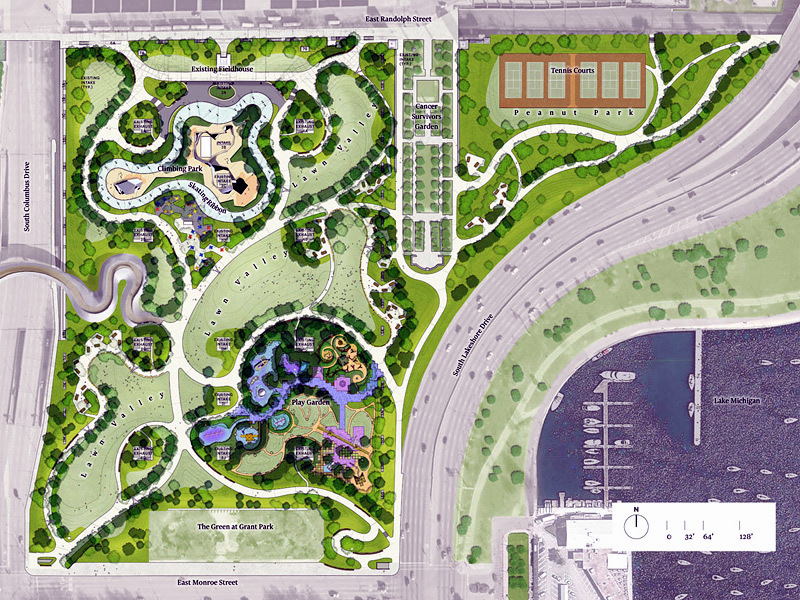
On this latest plan, we see that the park district consultants may have inspected this long standing resident and dog-walkers entrance and may have determined it was too difficult to grade properly. So they simply eliminated the planned paved pathway.
That was not the "solution" the neighbors have been advising was important as a continuing entrance/exit. In the future, residents would have to climb stairs from Lower Randolph/Harbor and walk across 6 lanes of traffic on Middle Randolph to get to Peanut Park.
It is important to listen to local voices and recommendations for park designers to learn how an area has been used for the last 5 decades.
They also added a Lake Viewing High Point between the tennis courts and the Cancer Survivors Garden. It will be a great sled hill. However, the consultants are also ignoring our earlier advice that a more direct bike route was desirable from Upper Randolph through Peanut Park to Middle Randolph - just by connecting the planned gap between the garden and the viewing Hill High Point.
Resident Access from Lower Randolph
For the last three years local residents have been advising the park district and their New York consultant that it is important to continue to provide access from Lower Randolph and Lower Harbor. Especially during inclement weather, dog walkers and bike riders in the neighborhood need a reasonably sloped (20:1 ratio or 5% is handicap accessible) pathway to Peanut Park. It has been used by local residents for the last 53 years, and will become more important as Lower Harbor is cleaned and the additional 6 high rise buildings are constructed in the north and northeast area of the New Eastside. The latest plan eliminates any paved pathway from this entrance.
6-13-2012
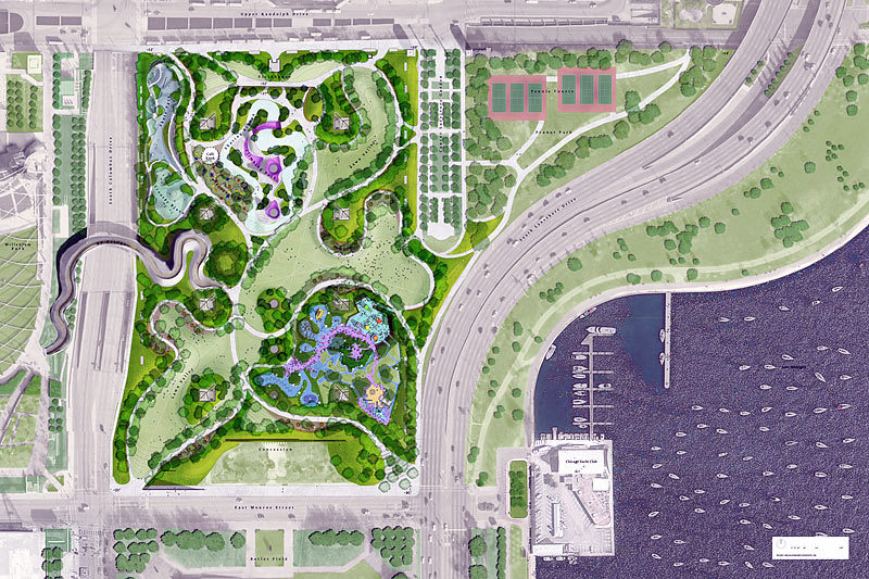
The Park District consultants finally got the existing entrance correct, however they apparently didn't look at the 30% slope, almost like climbing or descending a mountain. The pathway needs to be angled in a southwest direction, north of the 6 tennis courts. We have placed a "c" at the existing correct location.

1-13-2012
On this graphic, the park district and the consultant realized the importance of providing access for local residents, however they neglected to walk over and actually look at the entry point.
When the city moved the streets and sanitation downtown location to replace the auto pond (over a decade ago), that area where the pedestrian pathway ends in this graphic is a long 8-foot fence. We immediately told them of their oversight, and the response was the graphic above.
 | ||||||
| ||||||
"c"
"c"=correct location
"c"
12-12-2011
Note that the input that local residents provided at the several public hearings was ignored. No access to Lower Randolph/Lower Harbor was provided, even though it has existed for over 5 decades. We provided several pictures of the "desire path" that has been the reasonable slope access to Peanut Park on webpage:
"c"
10-26-2011
During several of the public hearings, the park district officials and consultants were reminded of the access to Peanut Park from our lower street system that had existed for over 5 decades.
Also some of the residents that moved to the New Eastside because of the existence of the 12 tennis courts requested that at least 6 of the courts be rebuilt in Peanut Park. The park district officials and their consultants recognized the need, added the 6 modern tennis courts, and assured the 400 Randolph residents that there would be minimum light spill from the shaded fixtures and the new court surface.
"c"

Please share your comments and opinions with your neighbors and the park district consultants.
These graphics are in reverse time order. The latest is on top. You may want to start by scrolling down to #1 at the end of the webpage.
| ||||||
<----
This is the most dangerous route from Millennium Park to Navy Pier via Middle Randolph to the Lakefront. The intersection under Lake Shore Drive is a dangerous mix of 22 lanes of low and higher speed traffic from surprise directions. The park district and the Chicago Dept. of Trans. should spend 1 hour studying graphics #7 thru #14 on this webpage link
Route "c" via a cleaned up and lighted Lower Harbor is considerably safer and crosses NO TRAFFIC LANES !!
An existing option from Upper Randolph is down Field Dr. to Lakeshore East Park to the river front and the STAIRWAY to the west side of the Lakeshore Drive bridge. That is BOTH attractive and safe (except not handicap accessible and needs signage).
5.
4.
3.
2.
1.
Please start with #1 at the end of this webpage.
Barriers added to discourage shortcut from BP Bridge
<----- <---------------
<---------Look-out/Sled Hill Added
ADA INDEX